Important Links
- Indiana Travel Status by County
- INDOT Road Information
- Interstate Cameras
- Closings and Delays – Fox59
- Cold Weather Safety and Protecting Your Home ***** NEW LINK ADDED
Weather Updates
1/26/2026 1:30 PM
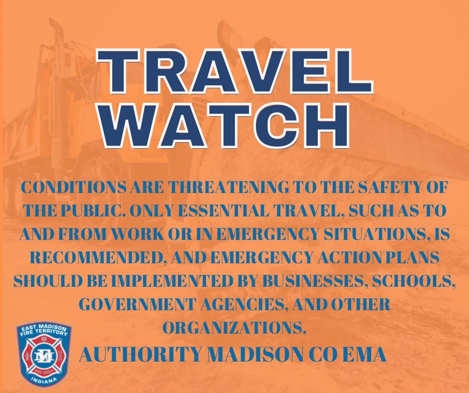
Madison County EMA has lowered the travel status back to a WATCH level.
Travel Watch Level Means that conditions are threatening to the safety of the public. During a “watch” local travel advisory, only essential travel, such as to and from work or in emergency situations, is recommended, and emergency action plans should be implemented by businesses, schools, government agencies and other organizations.
1/26/2026 10:00 AM
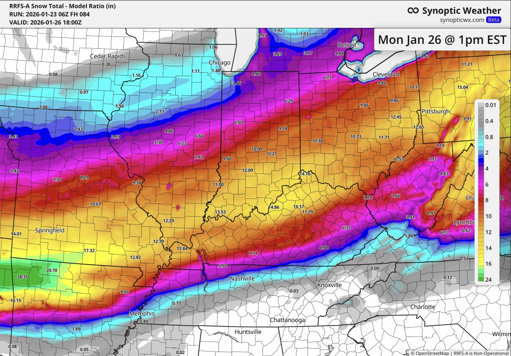
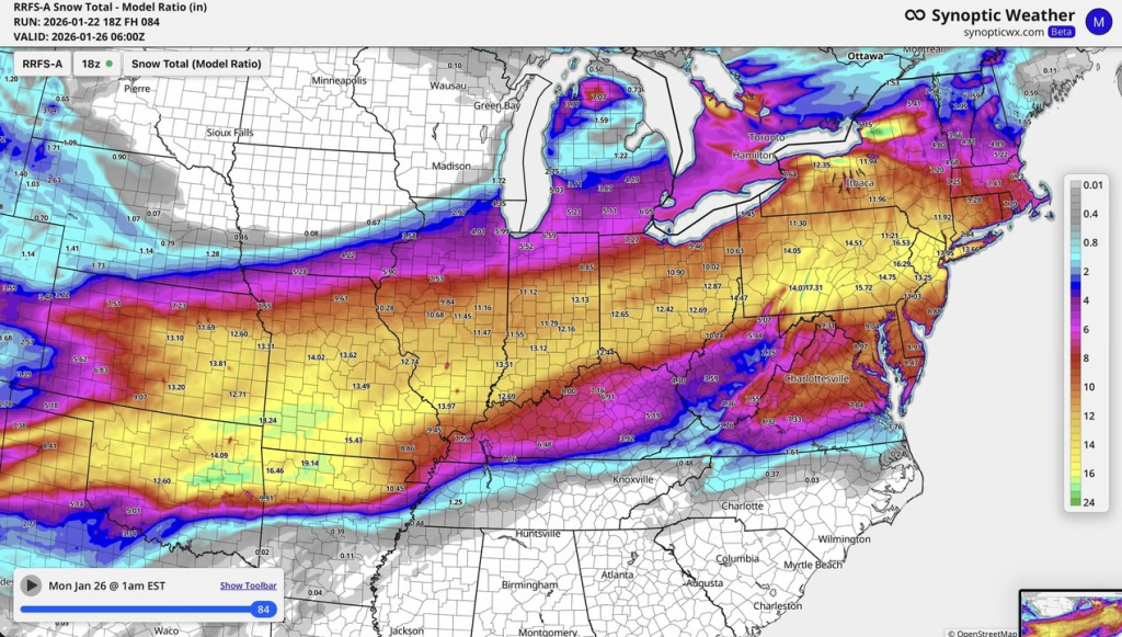
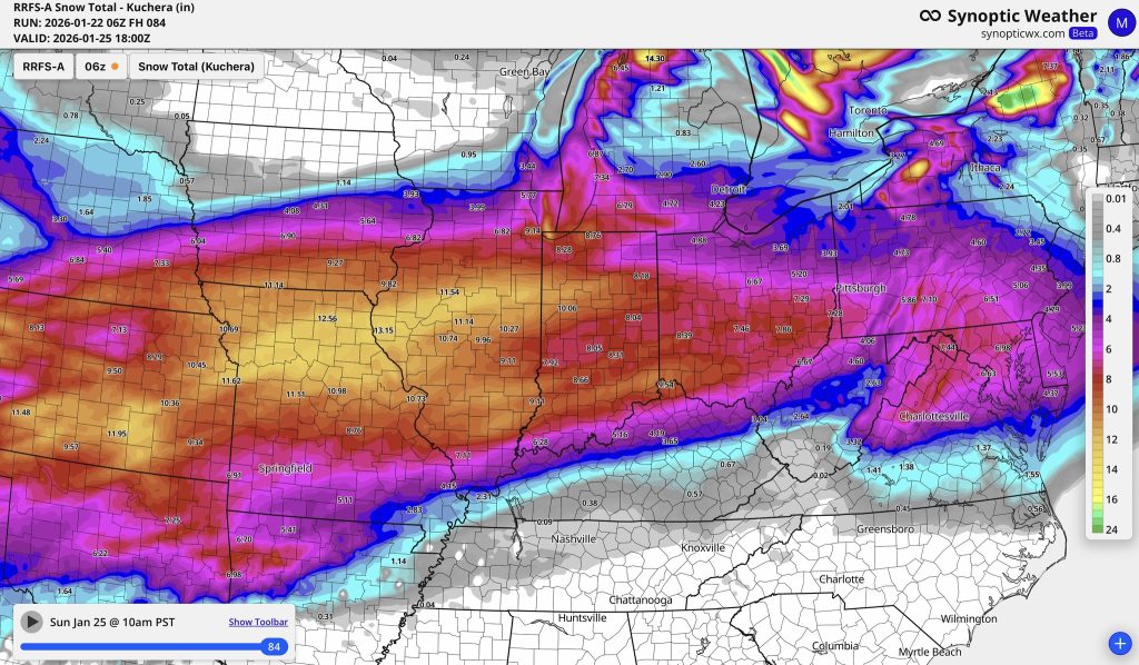
Windchill is currently -16F and is not going to improve much today. Snow moved out last night about 8PM, it looks like the official totals will be around 10″-12″ with a few isolated spots there may be more. Drifting on E/W roads has not been too bad overnight but thanks to the hard working town, city, county, and state snow plows they are making great progress on the roads.
We are still under a travel WARNING for Madison County and Travel WATCH for Delaware County. Both counties will evaluate their travel status later today and adjust accordingly.
Overnight the fire department was very quiet, but we remain staffed and ready to serve. Use caution when shoveling snow, this added physical work adds stress to your heart and cardiac system.
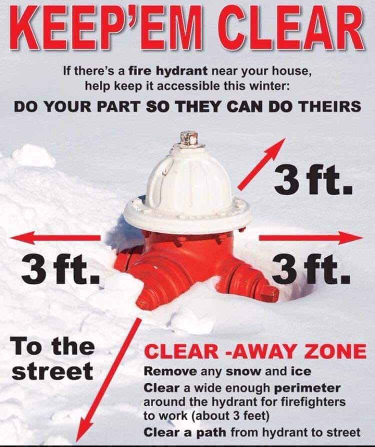
We are reminder citizens to please clear fire hydrants. We have already seen fire hydrants with piles of snow around them. At night this makes fire hydrants very hard to find as well as anytime, hard for us to get our hoses attached without taking time to shovel. While your house is burning, do you want us to be shoveling snow to get water on the fire? Please help us, so we can help you. Shovel at least 3′ in all directions of fire hydrants.
1/25/2026 6:00 PM
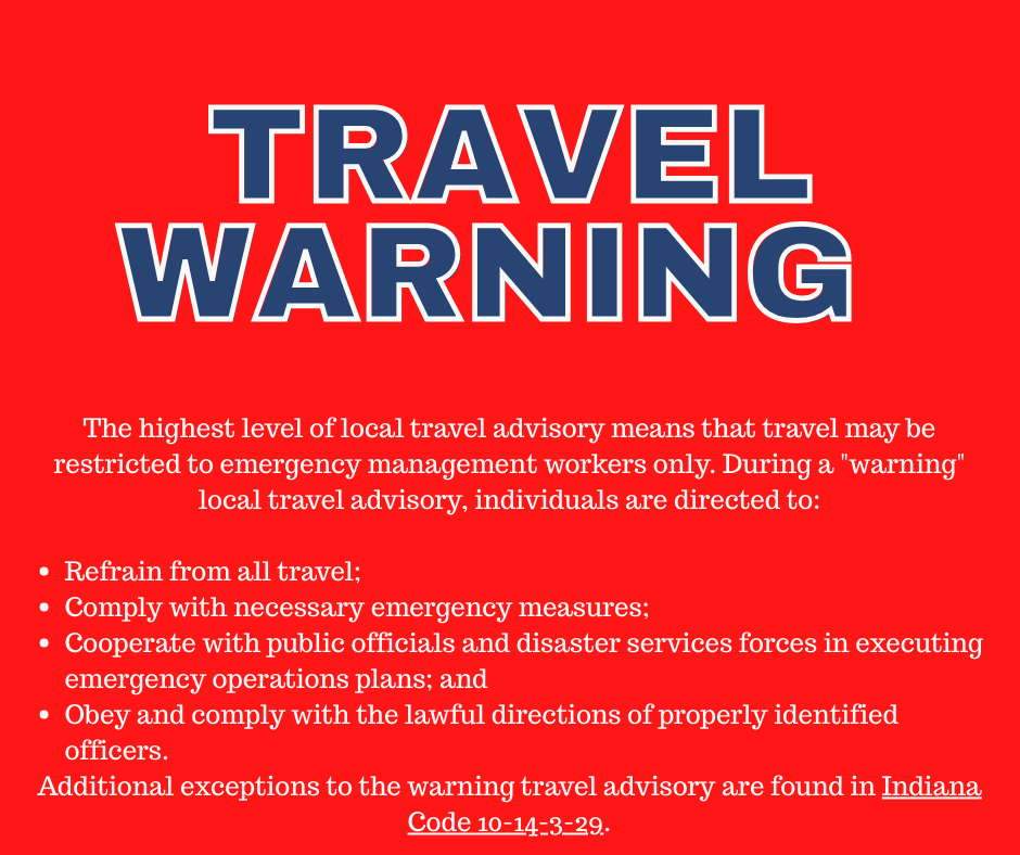
Madison County EMA has raised our travel status to red WARNING.
The highest level of local travel advisory means that travel may be restricted to emergency management workers only. During a “warning” local travel advisory, individuals are directed to:
- Refrain from all travel;
- Comply with necessary emergency measures;
- Cooperate with public officials and disaster services forces in executing emergency operations plans; and
- Obey and comply with the lawful directions of properly identified officers.
Additional exceptions to the warning travel advisory are found in Indiana Code 10-14-3-29.
1/2/26 12:00 PM update
The Herald Bulletin is reporting: Snow accumulation had reached 14 inches in Pendleton, 11 in Anderson and 10 in Elwood, according to The Weather Channel. Temperatures across Madison County were hovering around 10-15 degrees Sunday, with the wind chill making it feel like minus-5.
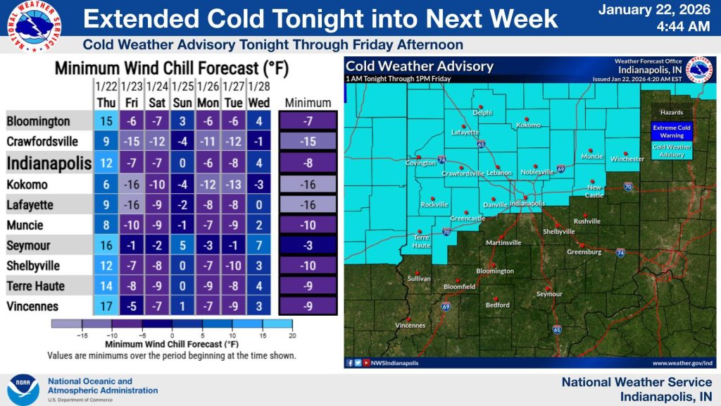
Overnight and Monday morning low temperatures with the windchill is expected -10 to -20 F, dangerously cold.
We continue to be under a WATCH travel advisory.
1/25/26 8:00 AM Update
Officially 6.2″ of snow on the ground in Anderson and it is still coming down. An additional 4″ – 6″ of snow is expected today.
Madison County EMA has elevated the travel status to WATCH.
Travel Watch Level Means that conditions are threatening to the safety of the public. During a “watch” local travel advisory, only essential travel, such as to and from work or in emergency situations, is recommended, and emergency action plans should be implemented by businesses, schools, government agencies and other organizations.
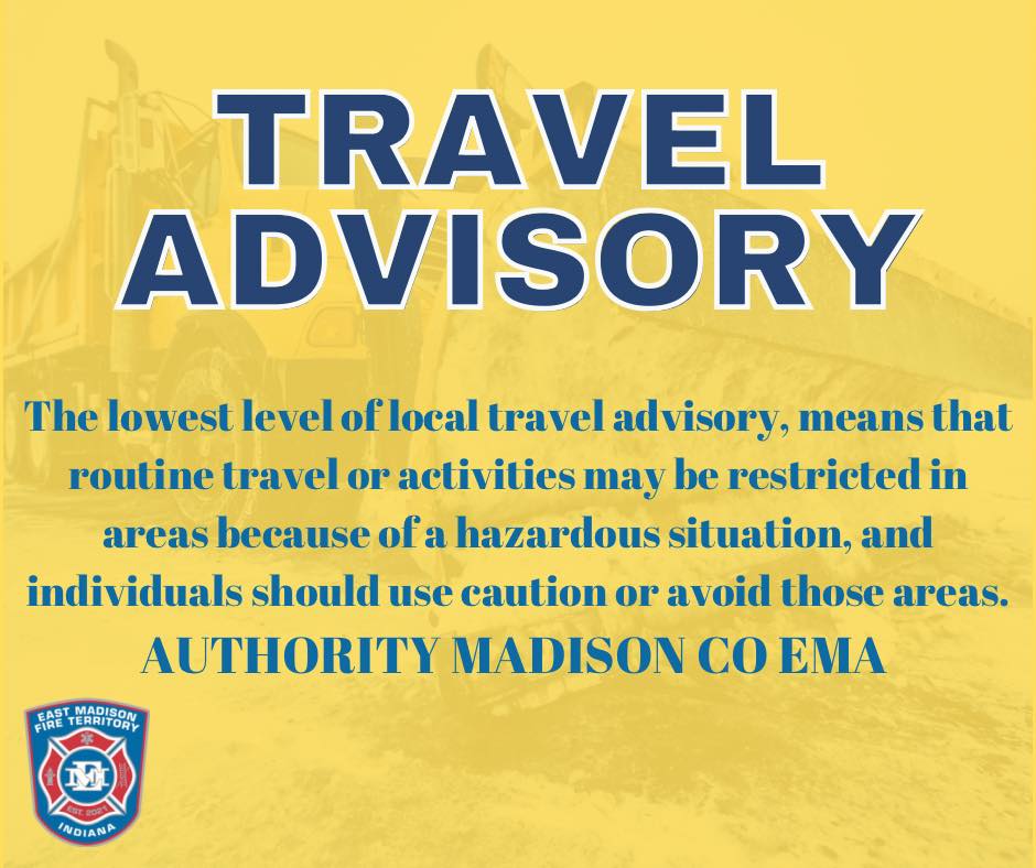
1/24/2026 7:00 PM
Madison County EMA has issued a travel ADVISORY for all of Madison County. Advisory is the lowest level of local travel advisory, means that routine travel or activities may be restricted in areas because of a hazardous situation, and individuals should use caution or avoid these areas.
1/24/2026 4:45 PM
Flurries have begun falling in Chesterfield, this is slightly earlier than expected.
What is EMFT doing to keep our community safe?
- Staffing extra Fire and EMS personnel at both stations, starting at 7:00 PM tonight thru the duration of the storm.
- Department 4-wheel drive vehicles staffed and equipped to respond if needed.
- Apparatus are equipped with blow torches to thaw frozen fire hydrants.
- Snow shovels and salt on our apparatus.
- Working directly with Madison Co. Highway Department to have plow trucks available to escort fire and ambulance apparatus when responding to rural portions of the territory.
- Working directly with the Emergency Operations Center to coordinate road conditions, and mutual aid requests if needed from other neighboring fire departments.
1/24/2026 07:00 AM
Not much change to the forecast, expected snow arrival is still between 7P-11P tonight. Heaviest snow will begin early Sunday morning (overnight Saturday night) and continue into the day Sunday. Travel on Sunday is going to be difficult, we expect travel restrictions to be put in place by Madison County EMA. The winter storm warning goes into effect beginning at 7:00 PM tonight thru Monday 1/26/2026 at 7:00 AM.
Extreme cold and prolonged single digit temperatures will cause water pipes to freeze. Recommend leaving a trickle of water running, leaving cabinet doors open to circulate air and making sure all crawlspace openings are sealed to reduce wind from getting underneath your home.
** Chesterfield Residents ** Please park in your driveway as much as possible to limit the amount of vehicles parked overnight and Sunday on neighborhood streets. This simple action will help street plows clear roads quicker and more safely. It also helps emergency crews in the event of a fire get thru more quickly.
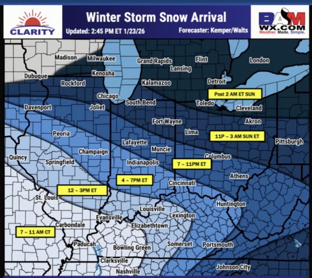
1/23/2026 10:00 PM
The biggest change to the forecast is in the expected arrival of snow in our area. Snow is expected to arrive between 7P-11P with significant snow overnight into the day on Sunday. This system is going to impact travel on Sunday, road conditions will be dangerous on Sunday. Wind gusts near 20-25MPH will cause blowing and drifting snow on rural roads.
1/23/2026 8:00 AM
The latest forecast this morning is calling for 10″ of snow in this part of central Indiana. We may see some light snow showers during the day on Saturday, but the main impact of the storm will be Saturday night after 7PM and the heaviest snow falling overnight into Sunday morning.
We expect significant travel issues on Sunday. We recommend staying home, allow the plows to do their job so we can get roadways cleared for emergency vehicles.
Chesterfield residents have been asked to park in their driveway starting Saturday evening and overnight. We understand not everyone can park in their driveway, but the more vehicles off the neighborhood streets will help not only emergency vehicles but the street department plows.
Extreme cold temperatures for the next 10 days will also make this storm system challenging. Overnight low temperatures between -2 to 4F most nights, with windchills below zero. Day time high temperatures only climb into single digits and low teens in the forecast.
1/22/2026 6:00 PM
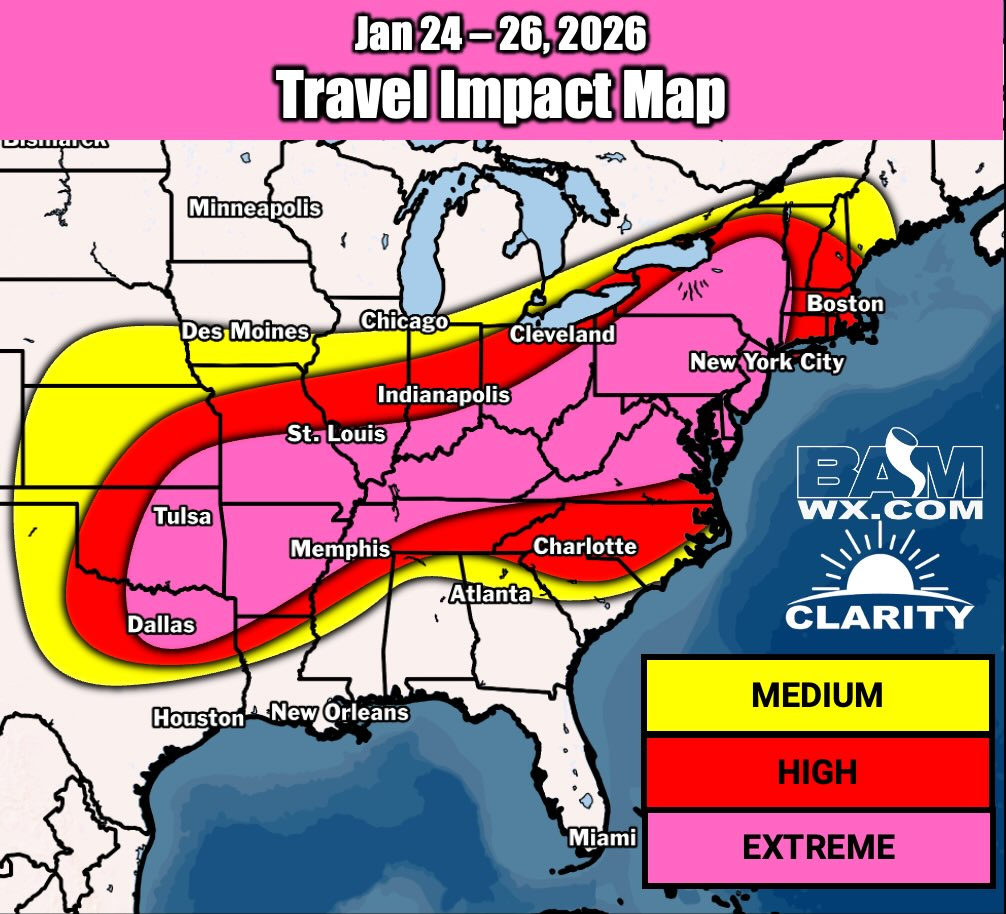
BAM weather has updated their forecast this evening and it now reflects 13″ for Muncie/Anderson corridor. The important piece to remember, the forecast will change +/- thru the the duration of the event. Never the less, we will get snow and everyone should be prepared for inclimate weather.
1/22/2026 1:00 PM
* Winter Storm Watch has been issued by the NWS until 7:00 PM Sunday night.
1/22/2026 Update 12:30 PM
BAM Weather is predicting Madison County, IN will be in the 6″-10″ range with southern part of the county being in the range of 6″-8″ and northern portion of the county being closer to the 6″ total. Snowfall is expected to begin Saturday afternoon between 2-5PM ET with the heaviest snowfall rates being after dark Saturday night and overnight.
Also, we have not talked about the bitter cold temperatures which will arrive with this storm and stay in central Indiana for the next week. Low temperatures at night will be 0F – 5F with windchill temperatures being sub zero. This morning’s low temperature (23F) is warmer than our high temperature the next 10 days as most days we are 10F-13F with a couple 21F mid next week.
Everyone will need to take steps to keep water pipes from freezing, and start vehicles which sit outside, as prolonged cold temperatures will cause fluids to gel or even freeze.

1/22/2026 Update 07:00 AM
The official forecast has not come out yet, but early indications are showing a 6″-10″ swath of snow thru central Indiana. Lesser amounts of snow to the south, but precipitation mixing with ice will make this a massive storm across the US.
Travel impacts will be high on Saturday, at this time, motorists should make plans to adjust travel to be on the road Friday or consider delaying until Sunday or even Monday if possible. We expect to be able to give a more concrete forecast later tonight. In the meantime, please begin making preparations at home and at work for a significant winter weather event.
Items to consider:
- If you have a generator, start it and make sure it runs properly
- Make sure you have fuel for generator
- Charge portable battery packs
- Make sure your shovel is near your front door or the garage
- Consider putting down salt on your driveway and sidewalks late Friday night
- Stock up on groceries
- Ensure you have medications needed.
- Fuel up your vehicle
- Make sure you have a small shovel, blankets, flashlight, batteries, and snacks in your car if you must travel.
1/21/2026 6:00 PM Update:
The page will be active for the upcoming winter weather event this weekend. 1/23/26 – 1/25/26. This page is intended to provide our followers and viewers a one stop page with up to date, vetted weather related information, primarily for the Town of Chesterfield, Union Township and Richland Township areas. Much of the weather information provided will be for central Indiana, Madison County, and other surrounding areas. The newest information will always be posted at the top of this blog.